menu_open
Hai Van Pass - The World's Most Heroic Pass
View font:
Hải Vân Pass is a mountain pass located at the southernmost point of Thừa Thiên Province, adjacent to the northernmost point of the present-day city of Đà Nẵng. This mountain pass is situated on the peak of Hải Vân Mountain, standing at an elevation of 496 meters above sea level. It holds strategic importance due to its vulnerable position in relation to the imperial capital Huế. The pass serves as a gateway and is positioned on the top of Hải Vân Mountain, providing a vantage point with an elevation that offers a strategic overview of the surrounding landscape. Historically, its significance lies in its role as a key location in the defense and control of the imperial capital, Huế.
Introduction:

Hải Vân Pass was constructed in the 7th year of Minh Mạng's reign (1826) and is situated atop Hải Vân Pass (also known as Ải Vân, Ngãi Lãnh, Ải Vân Sơn, Ải Lĩnh), on the western side of Hải Vân Mountain. It is positioned between the two peaks of Hải Vân Sơn (to the east) and Bà Sơn (to the west), at an elevation of 496 meters above sea level. The pass is part of the Bạch Mã - Hải Vân mountain range located in the areas of Lăng Cô town, Phú Lộc district (Thừa Thiên Huế province), and Hòa Hiệp Bắc ward, Liên Chiểu district (Đà Nẵng city). It is approximately 90km south of Huế city and about 28km north of the central area of Đà Nẵng.

Numerous historical documents have recorded the location and significance of Hải Vân Mountain and Hải Vân Pass. Works such as "Dư địa chí" compiled by Nguyễn Trãi in 1435 mentioned the toponym "Ải Vân." Dương Văn An in "Ô châu cận lục" (1555), Hòa thượng Thích Đại Sán in "Hải ngoại ký sự" (late 17th century), and Lê Quý Đôn in "Phủ biên tạp lục" (late 18th century) all described the vast and formidable nature of the mountain and the pass, highlighting its strategic importance on the route from Thuận Hóa to Quảng Nam. They noted that it served as a vulnerable point that required military presence. In the late 19th to early 20th centuries, comprehensive historical records such as Đại Nam nhất thống chí of the Nguyễn Dynasty and various maps published during that time, including Thừa Thiên toàn đồ (1832), Đồng Khánh ngự lãm địa dư chí đồ (1886 - 1888), and Đại Nam nhất thống chí (Duy Tân year 3 - 1909), clearly and in detail outlined the position of Hải Vân Mountain and Hải Vân Pass.

History:

In history, before the year 1306, the region with Hải Vân Pass belonged to two districts, Châu Ô and Châu Lý, part of the Kingdom of Champa. After the event where Princess Huyền Trân of the Trần dynasty married King Chế Mân, Hải Vân Pass became the border between Đại Việt (now Vietnam) and Champa. In 1402, during the Hồ dynasty, the Chiêm Động and Cổ Lũy regions were divided into four districts: Thăng, Hoa, Tư, and Nghĩa. Hải Vân Pass then became the boundary between the Hoa district and the Thăng Hoa route. From 1471, after King Lê Thánh Tông's military campaign against Champa, Hải Vân Pass was established as the border between Thuận Hóa and Quảng Nam provinces, becoming a strategically significant location on the North-South route, drawing special attention from various dynasties.

Since the Nguyễn lords took control of Đàng Trong (Southern Vietnam), Hải Vân Pass has been considered a precarious and strategically important position. Lord Nguyễn Hoàng (1558 - 1613) referred to it as the "yết hầu land of Thuận Quảng." In 1719, Lord Nguyễn Phúc Chu (1692 - 1725) expressed his awe while passing through Hải Vân Pass, describing it as a formidable and majestic place. In 1774, General Hoàng Ngũ Phúc of the Trịnh lords captured Phú Xuân and constructed a high embankment called Đỉnh Lũy right at the peak of Hải Vân Pass. King Quang Trung (1788 - 1792) gathered troops at Hải Vân Mountain to advance against the Trịnh forces in Phú Xuân. When Nguyễn Ánh advanced toward Phú Xuân, he ordered his generals to "approach Hải Vân Pass through the dangerous area and hold it."

Under the Nguyễn Dynasty, with Huế as the capital, Hải Vân Pass and Hải Vân Mountain became increasingly important for safeguarding the southern part of the capital. It served as an observation point overlooking the entire region, both at sea and on land. It was a strategic location for controlling virtually the only land route from the south to Huế and also exerting control over the maritime route passing beneath the mountain. Recognizing the significance of Hải Vân Pass, as early as the reign of Gia Long (1802 - 1820), the royal court established four relay stations in Phú Lộc district and improved the road leading to Hải Vân Pass. During Minh Mạng's reign (1820 - 1840), to encourage people living in this rugged mountainous area, the king rewarded each household with a tael of silver and built stone steps on steep sections of the road to facilitate travel.

Highlight:

Before the construction of Hải Vân Quan, Hải Vân Pass was considered a vulnerable position for Thuận Hóa - Phú Xuân - Huế both militarily and in terms of transportation. It served as the southern gateway to this region, but there were no large-scale, significant architectural structures for defense and control until the establishment of what is now known as Hải Vân Quan. Prior to 1826, military posts and guard stations were small and simple, not placing significant emphasis on military defense but rather on guarding the pass and the road stations. In the early 19th century, as Phú Xuân - Huế became the capital, Hải Vân Pass became increasingly important as the gateway to a prestigious region, requiring enhanced defense.

In February of the Bính Tuất year (1826), King Minh Mạng ordered the construction of a gate at the summit of Hải Vân Pass. The front of the gate was inscribed with the three words "Hải Vân Quan," and the back with the six words "Thiên Hạ Đệ Nhất Hùng Quan." Stone walls were arranged on both sides of the gate, with a structure made of bricks forming a vaulted entrance, similar to the gates in Huế, but without an ornate archway. Above the gate was a rooftop used for observation on all sides, with stairs for access. The construction took only a few months, with labor hired by Thừa Thiên Province and Quảng Nam Province. The government then sent troops to bring cannons to fortify the pass.

The management and defense of Hải Vân Quan were overseen by the Admiral of the Capital, under the authority of the local governor of Thừa Thiên Province. After the completion of the gate, the northern part fell under the administration of Thừa Thiên Province, while the southern part fell under Quảng Nam Province. Policies were enacted to encourage people to settle in the area, and a temple to worship the deity of Hải Vân Mountain was built.

In 1876, before the French colonial period, there were 50 guards stationed at the pass. By 1885, after the signing of the Treaty of Tientsin (1884), the number of guards had dwindled to about 5. In 1918, when H. Cosserat visited Hải Vân Quan for research, the gate had been abandoned and no longer guarded. In late 1946, during the return of the French, Hải Vân Quan was transformed into a stronghold with numerous fortified structures on the treacherous summit, occupied by two platoons of European and African soldiers. After 1954, the housing system, bunkers, and other structures continued to be used by the U.S. military and the government of South Vietnam.

Architecture:

Presently, the Hải Vân Quan historical site has undergone significant changes compared to primary historical records from the Nguyễn Dynasty, French sources from the early 20th century, and other documents during the period from 1946 to 1975. In 1918, when H. Cosserat conducted research on Hải Vân Quan, it appeared abandoned, but the structures were relatively clear in terms of location, scale, and construction. However, from 1946 to 1975, Hải Vân Quan and Thiên Hạ Đệ Nhất Hùng Quan were extended upward to increase the height of the gates for enhanced control. Some sections of the walls, terraced systems, internal paths, etc., were dismantled, lowered in height, or newly built away from their original positions.

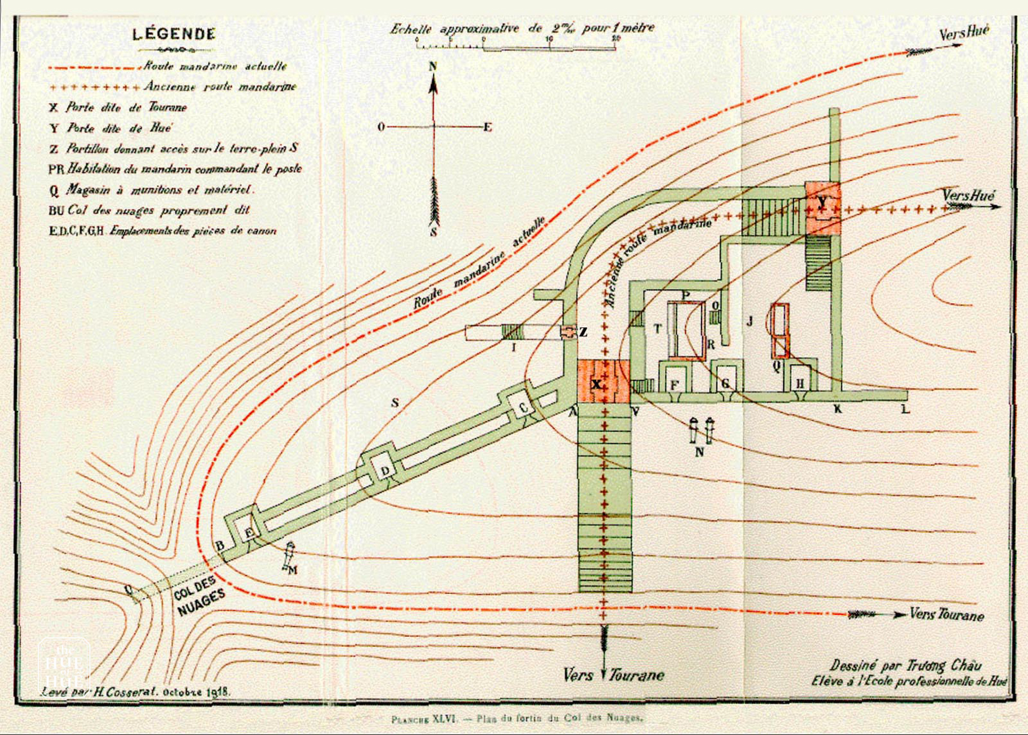
The strategic points such as artillery positions, headquarters, and arsenals were replaced by new military buildings, barracks, underground warehouses, and gun emplacements constructed by the French and later the U.S. military during their occupation. The entrance to Thiên Hạ Đệ Nhất Hùng Quan was sealed with modern bricks, buried under approximately 2 meters of soil and sand. The Thiên Lý road from the south leading to Hải Vân Quan and from Thiên Hạ Đệ Nhất Hùng Quan to Huế was flattened and filled in. Additionally, around Hải Vân Quan, French and American military units built five bunkers at vulnerable positions to protect the area.

After 1975, new structures like the Viba station, high-voltage power lines, and the Victory Memorial were constructed within the historical site, along with existing French and American military installations. These changes completely altered the original layout of the Hải Vân Quan historical site.

In general, Hải Vân Pass is not only a majestic and top-rated scenic spot in Vietnam - "Thiên Hạ Đệ Nhất Hùng Quan" but also a witness to many glorious achievements in the nation's history, particularly during the resistance wars against the French and the Americans (1946 - 1975).

The Hải Vân Quan historical site has been recognized as a National Heritage, and conservation, restoration, enhancement, and utilization of its values are crucial to restore its inherent significance, contribute to preserving the cultural heritage of the nation, and support economic development during the period of renovation and international integration.

Alongside Lăng Cô - Bạch Mã - Cảnh Dương, Hải Vân Quan is a point of attraction for domestic and international tourists, offering a chance to appreciate the magnificent beauty of mountains, forests, and the sea.

Experience Guide:

The conservation, restoration, and promotion project for the Hải Vân Quan historical site have a total investment of over 42 billion Vietnamese dong, sourced from the budget of Da Nang City (50%) and Thừa Thiên Huế Province (50%). The project is scheduled to be implemented over a period of two years and is being coordinated by the Center for Conservation of Hue Old Capital Monuments in collaboration with the Department of Culture and Sports of Da Nang City.

Photos of Hai Van Pass by the Hue of Huế: